Editors: This story was originally published in Issue 156 of our quarterly Tube Times magazine.
Imagine this: A beautiful seven-mile bike ride, elevated over the San Francisco Bay with no stop signs or traffic lights.
For many, the transbay connection means a sweaty BART ride screeching underneath the Bay, infrequent ferries or buses, adding to the traffic and congestion on the Bay Bridge or worse: “I think I’ll stay in San Francisco tonight.”
Connecting the East Bay to San Francisco with a beautiful pathway no longer has to be a part of your imagination. Soon enough, you’ll be able to bike from Oakland to Treasure Island. But what about getting all the way to downtown San Francisco?
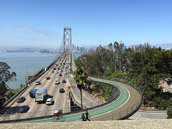
A rendering of the western span path.
Why?
Every day there is a new record for San Francisco’s population. With tens of thousands moving into San Francisco over the past few years, people are feeling the squeeze on our streets. We feel it already in the bike lanes. In 2015 alone, there were 25 percent more people biking on Market Street than in the prior year.
BART cars rolling through Embarcadero Station during commute hours typically offer no room for your bike. Passengers bringing their bikes onto Caltrain commonly get “bumped” with insufficient bike spaces on board. And, to no one’s surprise, a recent report by the SF County Transportation Authority confirmed what we all expected: The Bay Bridge is already at capacity.
The path for people biking and walking the Bay Bridge’s West Span represents not only an architectural accomplishment to bridge two cities separated by a bay, but also one of practical need. With projections of 10,000 people biking on the Bay Bridge daily, the completion of the West Span pathway will uphold the Bay Area’s dedication to environmentally-friendly and sustainable living.
Bridging the West
When it comes to a once-in-a-generation opportunity like building a bike path on the Bay Bridge, every step counts.
We’ve already taken the first step: a commitment by Steve Heminger, head of the Metropolitan Transportation Commission (MTC), the regional transportation agency for the nine Bay Area counties. At a Bike East Bay event in 2013, Heminger promised a path for people biking and walking that spans the entire Bay Bridge.
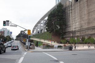
Possible landing at Beale and Bryant Streets.
Heminger’s announcement came towards the end of multiple studies led by Caltrans, the state’s department of transportation. Nearly a thousand pages were published to determine the feasibility of a path for people biking and walking on the West Span, the first of which was published in 2002 along with a more detailed study completed in 2014.
To hone in on the design and every fine-grain detail, the MTC awarded Arup North America a $10 million contract in November, 2014 to translate the reports’ findings into a real and feasible design. This hardworking team, led by Rafael Manzanarez and Rich Coffin, is eagerly turning a bikeable Bay Bridge into reality.
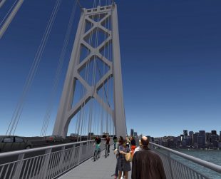
After a year of analysis, measuring everything from wind factors to cantilever physics and noise levels, Arup emerged in January, 2016 with stunning 3D images to share and gave the public the first real taste of what biking on the West Span could look like. From swirling ramps for ADA accessibility to glass elevators landing on the Embarcadero, the engineers and architects at Arup wowed the crowd, a packed, standing-room-only meeting earlier this year.
This project is complicated not only because of the immensity of a bridge structure but also because of the moving parts. Design has been broken into three distinct segments: the connection on Yerba Buena Island onto the West Span (pictured publicly for the first time on this Tube Times’ cover), the pathway on the span itself and the touchdown into downtown San Francisco. Several options have been developed for each segment, allowing for a menu of permutations to cook up the final three-course meal of the Bay Bridge West Span.
As this Tube Times went to print, the project managers at Arup confirmed that those designs pictured here are the preferred options based on feedback they received from the public. This special preview will be shared in full at an open house later this year before the final design options are brought to agency decisionmakers at the end of this planning process, which wraps up in early 2017.
After that, the next major step to turn three-dimensional computer-aided designs into real-life steel structures will be to identify the funding needed. Your SF Bicycle Coalition looks forward to working alongside project partners, our Bike East Bay allies and most importantly, our members to see this project through, currently projected for completion by 2026.
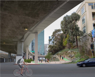
Possible landing at the Embarcadero near Harrison Street.
Completing the East Span
In Issue No. 100 of Tube Times, dated Oct.-Nov. 2004, the cover article was entitled “Biking to Oakland and Back.”
Back then, this was an otherworldly dream. The opening line read: “The grandest and potentially most popular multi-use pathways in the Bay Area exist only on paper.”
After two years of nearly-completed limbo, the East Span path for people biking and walking will finally touch down on Yerba Buena Island later this year to fully connect the East Bay to the edges of San Francisco. When complete, you’ll be able to ride from West Oakland and take the beautiful, 15-foot path named after long-time bicycle advocate and Bike East Bay founder, the late Alexander Zuckermann, all the way to Yerba Buena Island. There, you’ll land at a brand new vista point on U.S. Coast Guard territory where you can take in the sights.
As housing and commercial developments on Treasure Island are built out, so will the bike connections. This massive development project broke ground earlier this year and will transform both Treasure Island and Yerba Buena Island with new development and transportation networks, including bike-friendly and walkable streets, along with significantly improved access to and from the islands.
The grand visions your SF Bicycle Coalition dreamt up for the Tube Times 12 years ago are becoming a tangible, bikeable reality.
What’s next?
We have only come this far because of San Francisco’s love affair with the Bay and the momentum of bike advocacy. For more than a decade now, members of the San Francisco Bicycle Coalition, as well as Bike East Bay members, have shared a common dream: to someday bike shore to shore across the Bay.
The fight continues to make that a reality in this generation, and you can make a difference. Come to the next open house. Ride with us when the East Span makes its way to Treasure Island. Tell everyone you know and ask them whether they want to be part of a truly awe-inspiring, historic opportunity..